| Tucson Geology 101 Series |
Placed by: Azroadie
Placement date: May 24, 2007
State: Arizona
County: Pima
Nearest city: Tucson
Number of boxes: 10
Trail difficulty: varies from easy to moderate
Stamps hand-carved
Status:
Basalt: Alive and well
Gneiss: Alive and well
Granite: Alive and well
Limestone: Alive and well
Sabino Fault: Alive and well
Sandstone: Alive and well
Schist: unavailable
Schist 2: Alive and well
Shale: Alive and well
Tuff: Alive and well
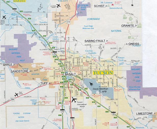
I am a geologist and am giving an introduction to the geology of the Tucson area through letterboxing. The letterboxes are scattered all around the fringes of Tucson. They are listed in a sort of geologic order and not in any particular finding order. You may search for them in any order that is convenient for you. See the map below for the general locations of the letterboxes.
Intrusive rocks, also called plutonic rocks, are formed by the cooling and hardening of magma deep within the earth surrounded by pre-existing rock. The magma cools slowly, and, as a result, the rocks are coarse-grained and the mineral crystals may be easily seen with the unaided eye.
==> Granite Letterbox: This box is along the Catalina/Mt. Lemmon Highway in the Coronado National Forest northeast of Tucson. Driving towards Tucson from the east on I-10, take exit 275 and go north on Houghton Rd. Turn right on Catalina Highway. Going towards Tucson from the north on I-10, take exit 256 and drive east on Grant Rd. Turn left on Tanque Verde Rd. Turn left on Catalina Highway. Drive up the Catalina Highway and after passing milepost 11, turn left into the Chihuahua Pine & Bear Canyon Picnic Areas. There is a fee to park (if you do not have an appropriate national pass). Walk difficulty moderate, there is no trail, you do a little boulder hopping and a short uphill scramble at end. Walking distance about 1/10 mile one way. From the northwest corner of the restroom, go at about 340 degrees (from mag. north) across the wash to the mouth of a moderate size gully. Walk up the gully. Continue past a 3 ft. high cut flat-topped stump almost in the middle of gully. You will then arrive at a large (about 7-8 ft. high) rounded boulder balanced on flat rock in the middle of the gully (in front of you and a short distance beyond the rounded boulder you will see a humongously large boulder with a tall dead tree (snag) behind it). From the northwest side of the rounded boulder, go at about 294 degrees up slope for about 47 steps to a tall live Pine Tree (the left one of two tall trees). From that tree, go at about 340 degrees for about 17 steps to a flat rectangular boulder in the middle of a cluster of moderate size live and dead Oak Trees (several of the dead trees are bent way over). The box is under the north side of the boulder under a rock.
The white rock you have been walking over is "granite". It is composed mostly of the minerals quartz (gray waxy color), feldspar (white color), mica (very dark silvery color), and garnet (dark red color). Geologists have named this rock the Wilderness Suite Granite and determined it to be of Eocene age. It is one of the rock types that form the core of the mountain range.
Volcanic rocks, also called extrusive rocks, are formed on the earth's surface by volcanic activity. Rocks formed from the molten volcanic material, or lava, are generally fine-grained because the lava cools quickly.
==> Basalt Letterbox: This box is in Sentinel Peak Park (aka "A" Mountain) on the west side of Tucson. From I-10 take exit 258 and go west on Congress Street for about 0.7 miles. Turn left (south) on Cuesta Avenue and follow it as it curves right and becomes Sentinel Peak Road. Just after entering the park, turn into the first parking area on the right. Walk difficulty mostly easy, the trail goes a little up hill and is a little rocky and you do a little off-trail hiking up a slope. Walking distance about 0.2 mile one way. From the lot, walk a short distance south to the large tan trapezoidal shaped "Sentinel Peak Park" sign. Behind it is a sign for the "Sentinel Ridge Trail". Walk up this trail. The trail will go slightly up and then will gradually descend into a gully and then just before it reaches the deeper center channel of the gully the trail will make a sharp turn to the left. Just after the turn, there is a black boulder on the right side of the trail. From that boulder, go at about 90 degrees (from mag. north) for about 60 steps up slope to a moderate size Palo Verde Tree with a Prickly Pear Cactus in front of it. The box is on the south side of the tree under the outer edge of the tree canopy under a larger flat basalt rock covered with some twigs and plant debris.
The black rock in this area is "basalt". It forms from lava that flows out of volcanoes or fissures in the earth. It is very fine grained and is composed of minerals rich in iron and low in silica. Much of the basalt in this area has numerous small spherical shaped holes called vesicules. They are formed from gas bubbles trapped in the cooling lava. This rock is called the "A" Mountain Basalt and is Miocene in age.
[The "Sentinel Peak Letterbox" is in this area.]
==> Tuff Letterbox: This box is in Tucson Mountain Park a little west of Tucson. From I-19 take exit 99 and drive west on Ajo Way for about 2.8 miles. Turn right into a trailhead parking area (it is well hidden in a natural area and there are no homes in the area). Or, traveling east from the Ajo Way/Kinney Rd. intersection (McDonalds on corner), drive east for about 2.3 miles and turn left (across the median) to the trailhead. The short access road to the trailhead is gravel/dirt; and, the parking area is small and uneven gravel/dirt. There are metal cut-out signs along the access road and at the gate that read "Pima County No Dumping". There is a brown gate along the north edge of the lot and a trail access entrance to the right of the gate. Walk difficulty fairly easy, the trail is flat, but it is rocky. Walking distance about 1/10 mile one way. Go through the trail entrance and walk north on the trail. You will soon arrive at a junction (a well used trail goes to the left and down). Go straight (right) on the old 4-wheel road and walk for about 75 steps to where the trail makes a right turn slightly up slope. At this turn on the left and slightly behind you is a Saguaro Cactus and also on the left are two Barrel Cactus. Take this right turn on the faint 4-wheel road/trail that goes at about 32 degrees (from mag. north) up slope. Walk up this trail for about 62 steps to a tall (about 15 ft.) armless Saguaro on the right with a small (about 2 ft.) Saguaro directly in front of it. Walk up the slope about 10 steps to this tall Saguaro. The box is on the east side of the Saguaro between it and a Jojoba Bush. It is covered with some rocks and plant debris.
The rock in this area and in the cliffs above is "tuff". Tuff is composed of a mixture of volcanic ash, pumice, volcanic glass, cinders, bits of various other volcanic material, and some crystals of the minerals feldspar and quartz. Geologists call the tuff in this area "welded tuff" because it has been compressed into an exceedingly hard rock. Tuff is formed from pyroclastic flows that rolled down the slopes of volcanoes. The rock in this area is named the Cat Mountain Tuff and it formed during the Cretaceous Period. The Tucson Mountains are the remnants of a very large explosive volcano.
Metamorphic rocks are previously existing rocks that have been deeply reburied and subjected to intense pressure and heat causing the minerals to wholly or partially recrystallize.
==> Gneiss Letterbox: This box is along the Catalina/Mt. Lemmon Highway in the Coronado National Forest northeast of Tucson. See the "Granite Letterbox" for directions to the highway. Drive up the Catalina Highway and look for the large wood odd-angular Coronado National Forest sign (it is just after a series of metal info signs). Continue past the sign for about 0.8 mile to the small pullout trailhead parking on the left side of the road for the Soldier Trail. Walk difficulty moderate, the trail is steep and rocky and you do a little boulder hopping at end. Walking distance about 1/10 mile one way. Walk up the Soldier Trail which goes steeply up the bottom of a small gully. The trail will then flatten out for a very short distance. At that point there is a large long flat boulder on the right side of the trail, guarded by a tall one-armed Saguaro Cactus on the left side of trail. Stand on the southern tip of the boulder and go at about 108 degrees (from mag. north) for about 20 steps to a tall Saguaro Cactus with 4 small arms (you will have to walk around the right side of a Palo Verde Tree to get to it). The box is 2 steps west of the Saguaro in a crack between two rocks and covered with some rocks and plant debris.
The rock you have been driving by and walking over is called "gneiss". It bears some resemblance to granite; however, it has a distinctive layering of alternating dark & white bands, a characteristic of gneiss. It is composed of the same minerals as granite: quartz, feldspar and mica. This rock is named the Catalina Gneiss and is of Oligocene age. It was formed from perviously existing granite that was deeply reburied and subjected to pressure and heat causing the minerals to recrystallize and form into layers. The Catalina Gneiss forms the southern front of the Santa Catalina Mountains and laps on to older metamorphic and granitic rocks that form the core of the mountain range.
==> Schist Letterbox: unavailable; the trail is closed due to hazards from a recent forest fire. This box is along the Catalina/Mt. Lemmon Highway in the Coronado National Forest northeast of Tucson. See the "Granite Letterbox" for directions to the highway. Drive up the Catalina Highway almost all the way to the village of Summerhaven. At the junction for Summerhaven, turn right on the road to Ski Valley (Ski Run Rd.). Drive past Ski Valley [the "Mt. Lemmon Aspen Letterbox" is near here], and continue up the paved road to its end. Just before the gate with the road closed sign on it, turn left into the trailhead parking area. There is a fee to park (if you do not have an appropriate national pass). Walk difficulty moderate, the trail is on an old dirt road; however, it is rocky and steep. Walking distance about 1 mile one way. Walk on the trail which begins left of the power station, continuing past the green utility building on the left. At the dirt road intersection, continue straight on the dirt road/trail. At the small metal trail sign on right, continue straight on Mt. Lemmon Trail #5. At the next trail sign on left, continue straight ahead. You will then arrive at a gray metal utility building on the right. Continue up the road for about 45 steps to a cut or steep slope on the right. The dark rock in this cut is "schist". Continue up the trail into an area of large live Pine Trees. Where the road curves to the right, look to your left and you will see an unofficial trail going off at about 200 degrees (from mag. north). Walk down this trail for about 29 steps to a cluster of 4 moderate size Pine Trees right in front of a humongously large boulder. From the first tree, go at about 80 degrees across slope for about 26 steps to a moderately large flat tilted white boulder. The box is on the north side of the boulder under some flat schist rocks.
==> Schist 2 Letterbox: This letterbox is an alternate for the Schist Letterbox. It is also along the Catalina/Mt. Lemmon Highway in the Coronado National Forest northeast of Tucson. Drive up the Catalina Highway past where Mile Marker 22 would be, and before MM 23, turn left into Sunset Trailhead at E. Sykes Knob Rd. Park immediately after making the turn (no fee). (In the roadcut on the left side of Catalina Highway just after this intersection schist and phyllite may bee seen). Walk difficulty mostly easy, a short stroll. Walk west up the paved road which then turns to dirt curving to the right up hill. Walk to the yellow hazard sign on the right side of the road that says "ENTERING BURN AREA FALLEN ROCK AND DEBRIS FLASH FLOOD AREA". From the sign walk east on an old eroded dirt road for about 35 steps. Turn to your left and walk about 14 steps to an 8 foot long log on the ground sawed off at both ends. The box is under the backside of the southeast end of the log about 2 feet from the end under a flat schist rock.
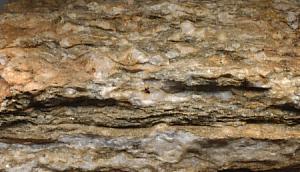
"Schist" has a very characteristic look. It is dark gray and shiny and consists of thin layers of mostly the silvery colored mineral mica and a small amount of quartz. It has been formed from older sedimentary rock that has been deeply reburied and subjected to intense pressure and heat causing the minerals to recrystallize and transforming it into much differently looking rock. This rock has been named the Pinal Schist and is Precambrian in age (about 1.65 billion years old). It is generally considered to be the oldest rock in southern Arizona. The rocks here are part of the core of the mountains and have been highly fractured by faulting -- some of the other rocks in this area include the metamorphic rocks phyllite and quartzite and the intrusive rock pegmatite.
Sedimentary rocks are formed from the cementing together of particles resulting from the chemical or mechanical weathering of previously existing rocks. They may also form from materials that precipitate as crystals and accumulate in layers in bodies of water.
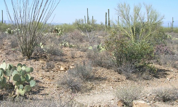
==> Sandstone Letterbox: This box is in Tucson Mountain Park a little west of Tucson. From I-10, take exit 257. Drive west on Speedway Blvd. (which changes its name to Gates Pass Rd.) and over Gates Pass. After going over the high point in the pass, continue down the other side for about 1.2 miles to the third parking pullout on the right (pullout #G7). Or, if you are driving east on Gates Pass Rd. from the Kinney Road intersection, go 1.1 miles from the intersection to the parking on the left. Walk difficulty slightly moderate, the dirt desert trail is mostly flat but somewhat rocky. The walk distance is about 1/4 mile one way. From the lot, between two purplish color boulders, walk west on the wide trail staying between the road and the south side of the wash. The trail then drops down and turns right across the wash. Continue north a short distance to stone steps on the left and walk up hill on the trail. The trail in this area is usually marked with some rock cairns to help locate it. The trail then meanders through the desert to a a "T" trail junction. Turn right and walk a short distance to a small gully with rock steps on the other (east) side of the gully. From the gully continue on the trail for about 20 steps. Turn to the right and you will see just off the trail a small linear depression or excavation in tan sandstone rock leading up to the base of a large Ocotillo. *** This place along the trail is shown in the picture below.*** From this point on the trail, walk left off the trail at about 22 degrees (from mag. north) for about 30 steps to a topless Saguaro Cactus with 4 arms. From this Saguaro, go at about 242 degrees for about 10 steps to an Ocotillo between two Jojoba Bushes. The box is on the west side of the Ocotillo under some rocks and plant debris.
The tan rock exposed around and near the small depression by the trail is "sandstone" which is composed of sand grains compressed and cemented together. This particular sandstone is a type called "arkose" which has grains composed mostly of the mineral feldspar. It was formed from sand deposited in a large inland lake. The rock here is named the Amole Arkose and is Cretaceous in age. Some fossils including dinosaur bones have been found in this region. The sedimentary layering or bedding of the sandstone is noticeable on both sides of the trail here and strikes from the northwest to the southeast across this area.
|
==> Shale Letterbox: This box is in Tucson Mountain Park a little west of Tucson. From I-10, take exit 257. Drive west on Speedway Blvd. (which changes its name to Gates Pass Rd.) and over Gates Pass to the intersection with Kinney Road. Turn right on Kinney Road and drive past the Desert Museum to the intersection with McCain Loop Road (this is the 2nd or western intersection with McCain Loop Rd.). Just past the intersection turn into the parking area on the left. There is a large brown park rules sign on east end. Walk difficulty moderate, there is no trail and you walk over a rock and cactus studded terrain, and down a very steep loose slippery slope! And, you might have some problems following the clues because you have to dodge around some large bushes and cactus making it diffficult to follow the bearings and keep count of the steps! However, the walk distance is only about 0.1 mile one way. Walk back to the intersection and cross the road to a directional sign reading "Tucson - Old Tucson - Desert Museum - Saguaro Nat'l Park. From the west end of the sign, go at about 358 degress (from mag. north) for about 22 steps to a Saguaro Cactus. From here you will have a good view of where you will be going. Look for the various Saguaro mentioned in the clues. From this Saguaro, go at about 342 degrees for about 73 steps down a steep loose rock slope to a tall Saguaro with 6 arms slightly curved and twisted (and one arm is broken). From the north side of this Saguaro, go at about 342 degrees for about 50 steps to an about 9 feet tall dead Saguaro skeleton. From north side of this Saguaro skeleton, go at about 338 degrees for about 32 steps to a long dead Saguaro skeleton on the ground. The box is under the arm joint under some rocks and plant debris. Now, walk north for about 17 steps to see an outcrop of dark red shale.
"Shale" is a very thinly layered and very fine grained sedimentary rock. The shale in this area was formed from mud deposited by running water in an inland basin and lake. This shale and other red sedimentary rock including sandstone and conglomerate form the red hills in this area. The red color comes from the iron oxide in the rock derived from volcanic debris. This sedimentary rock here is named the Recreation Red Beds and is Jurassic in age.
==> Limestone Letterbox: This box is in Colossal Cave Mountain Park southeast of Tucson. From I-10 take exit #279 and drive northeast/east on Vail Road/Colossal Cave Road. Continue on Pistol Hill Road. Turn right on Old Spanish Trail. After passing the entrance booth, turn left to the parking lot for Colossal Cave and park at the northeast end of the lot. Walk difficulty fairly easy, the trail is fairly flat; however it is a little rocky. Walking distance about 0.1 mile one way. Walk to the northeast end of the parking lot. Go down the exit road for about 24 steps to a trail on the right going northeast up slope. Walk 25 steps along the trail to a Prickly Pear on the right edge of the trail. Look right, upslope to an Ocotillo and Palo Verde. Look below the Ocotillo, a little to the left, at the base of a Limestone ledge with a dark stripe leading to the ground. The box is under one rock.
The grey rock in this area is "limestone". It is extremely hardened and crystallized lime mud that accumulated from calcium carbonate precipitating out in a large body of water. This rock was formed in an ocean environment, and, some marine fossils are found scattered throughout this limestone. The rock is named the Escabrosa Limestone and is Mississippian in age. Colossal Cave was formed in this rock by acidic groundwater dissolving away the limestone.
A fault is a fracture in the earth along which there has been some movement, or displacement, parallel to the fracture.
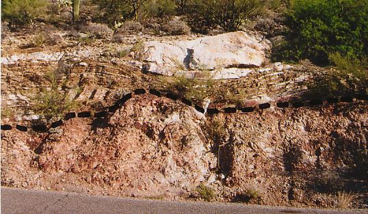
==> Sabino Fault Letterbox: This box is in Sabino Canyon Recreation Area (USFS) a little northeast of Tucson. Going towards Tucson from the north on I-10, take exit 256 and drive east on Grant Rd. Turn left on Tanque Verde Rd. Turn left (north) on Sabino Canyon Road and take it all the way to the entrance of Sabino Canyon Recreation Area on your right. There is a fee to park (if you do not have an appropriate national pass). Walk difficulty easy, a short uphill scramble at end. Walking distance about a mile one way. From the parking lot walk northeast to the paved Sabino Canyon Road. Walk northeast on the road to the top of the first hill (there is a round iron sewer cover on right). Continue down the road for about 125 steps to a road cut on your left. The Sabino Canyon Fault may be seen in this roadcut. *** The photo below is of this roadcut and the fault line is clearly delineated on it.*** Continue down the road for about 75 steps to the Bluff Trail sign on the right. Turn right and walk down this trail a short distance to where it crosses a small gully. From that crossing, continue up the trail for about 38 steps to a small flat pointed boulder on the right edge of the trail and pointing to the trail. Turn right and go off the trail up the slope for about 23 steps to three large boulders (for easier access to the boulders, continue up the trail for 7 more steps and then turn right and go up the slope to the boulders). There are two steel rods sticking out of the ground at these boulders. The box is between the first and second boulders under some rocks, twigs and plant debris.
The Sabino Canyon Fault runs nearly horizontal through the roadcut. Nicely banded black & white gneiss rock is above the fault and pinkish crushed rock is below the fault. The crushed rock was caused by the grinding movement of the fault. The fault extends a long distance up the canyon and caused the opening in the earth where erosion eventually formed the deep canyon.
|
[The "Sabino Canyon Letterbox" is also in this general area.]
Please be sure the contents of the boxes are double ziplocked when you put them back in the boxes (i.e. the stamp is in a ziploc, the book is in a ziploc, and the two are in the larger ziploc bag). Please rehide the boxes very well as described in the clues so that they can not be seen from any direction.
If you are interested in what the geologists' names for the geologic time periods represent in actual years, go to this "geologic time scale".
Contact me if any of the boxes need attention: http://nostalgia.esmartkid.com/azroadie.html.
Please record your find at http://www.letterboxing.org/ or at http://www.atlasquest.com/.
These letterboxes were placed for National Letterboxing Day, May 24, 2007.
I wish to thank Funhog of Portland, OR, for suggesting this project and its name.
|
Caching & Stashing NetRing | |
Geology NetRing | |
![]() Return to top
Return to top
![]() Return to My Letterboxing Activities main page
Return to My Letterboxing Activities main page