| | Historic U. S. Highway 666 on Vintage Postcards |
This exhibit displays vintage postcards of views, scenes, and businesses along historic U. S. Highway 666. They are regular size (3 1/2 x 5 1/2 inches) postcards published from the late 1920s to the 1960s. They are displayed in travel order going north from Arizona to Utah. The postcards show views that were seen by travelers from right along the highway unless otherwise noted. The age estimates for the unused postcards are based mainly on automobiles in the views and on postcard style. However, some estimates may be off by half a decade.
The actual text printed on the postcards is in quotation marks. My comments are in brackets.
CONTENTS
| Introduction | Pirtleville, AZ to Alpine, AZ | Eagar, AZ to Lupton, AZ | New Mexico | Colorado and Utah |
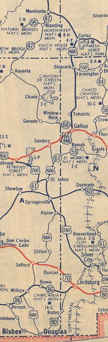
U. S. Highway 666 was one of the original U. S. numbered highways established in 1926. It originally extended from Gallup, New Mexico, north to Cortez, Colorado. In 1938 it was extended west and south to southeast Arizona, and in 1970 northwest to southeastern Utah. At its longest alignment, its southern terminus was at the junction with U. S. 80 near Pirtleville about 2 miles west of Douglas, Arizona. Its northern end was at Monticello, Utah, at the junction with then U. S. 160 and State 47 (now U. S. 191). Between Sanders, AZ, and Gallup, NM, Highway 666 shared the alignment with "The Mother Road" -- U. S. Highway 66.
From the very beginning, U. S. 666 was a rather unusual Federal highway. Numbering guidelines for U. S. highways reserved the even numbers for east-west highways. However, curiously, Route 666 was a north-south highway. Also, it had a bad reputation with certain religious groups because of the common belief that 666 is the "number of the beast"; thus, it was given the nickname "The Devil's Highway".
Because U. S. 666's parent highway U. S. 66 was eliminated in 1985, it was believed to be a cursed highway, and the highway signs were repeatedly stolen. Starting in 1985 portions of its alignment were decommissioned. U. S. Route 666 officially ceased to exist in 2003. The section in Arizona was renumbered to U. S. 191. The alignment in New Mexico, Colorado and Utah, was changed to the new U. S. 491.
Here is a scan of a portion of the United States map in the 1950 edition of the Rand McNally Road Atlas... showing U. S. Highway 666:

Exhibit created by Jack Mount
These pages were last updated on: February 26, 2024
Copyright © 2007-2024
![]() Return to List of My Postcard Exhibits
Return to List of My Postcard Exhibits
![]() Return to Postcard Resources Page
Return to Postcard Resources Page
![]() Return to first page of Jack Mount's Home Place
Return to first page of Jack Mount's Home Place
Highways & Roads NetRing | |
|
Postcard Collecting NetRing Power By Ringsurf |
|
Free Sites NetRing Power By Ringsurf |