By Jack Mount
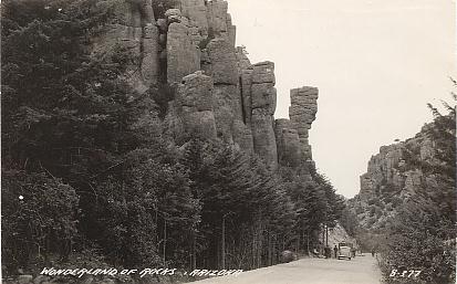
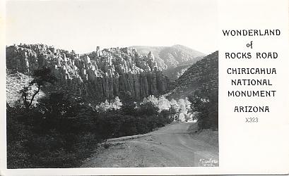
Nestled in the central part of the remote Chiricahua Mountains of far eastern Arizona lies a rugged wonderland of spectacular rock sculptures. In fact, from the earliest days of the pioneer settlers, this area was called the "Wonderland of Rocks". Today it is known as Chiricahua National Monument, a 12,000-acre area administered by the U. S. National Park Service.
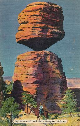
The scenery is dominated by a fascinating variety of rock formations -- massive stone columns, towering rock spires, and balanced rocks perched precariously on small pedestals. The origin of these rocks goes back 27 million years ago when volcanic eruptions in the area spewed forth red-hot pumice and ash. Cooling and later compaction produced a moderately-dark-gray rock known as rhyolitic tuff. From 25 to 5 million years ago movement in the Earth's crust produced uplifted blocks, one of them the Chiricahua Mountains. Weathering and erosion processes -- water, wind and ice -- carved along vertical cracks in the rock, known as joints, sculpting the forms we see today.
With the opening of the region to the development of mining and logging and other commercial exploitation, local residents -- prominent among them Ed and Lillian Riggs -- began to promote the area as worthy of national attention. Finally, on April 18, 1924, President Calvin Coolidge established the National Monument. President Coolidge concluded that "…certain natural formations known as 'the Pinnacles' are of scientific interest, …the public interests will be promoted by reserving as much land as may be necessary for the proper protection thereof, as a National Monument."
Although the unusual rock scenery is given the spotlight of publicity, the rich flora and fauna is just as unique. What makes these plants and animals special is the unusual number of Mexican species -- life found in the Monument is more like that found in the Mexican Sierra Madres. Most conspicuous are unusual birds such as Hepatic Tanager, Red-faced Warbler, and Elegant Trogon, and Mexican trees such as Chihuahua Pine and Apache Pine. One botanical specialist has stated that the Monument "contains a greater range of plant life than any area of equal size in the country."
The name of the Monument, and the mountain range, honors the group of Native Americans known as the Chiricahua Apaches, a band of people notorious for their occasional predatory attacks on other tribes and later on Mexican and Anglo settlers. For hundreds of years this region was their homeland, and they called the area that is now the Monument "Land of the Standing-Up Rocks." "Chiricahua" means "great mountain" in the Apache language. Names of their chieftains, such as Cochise, Geronimo, Massai, and Victorio, as well as the name of their tribe, survive today as geographic placenames in southeastern Arizona.
A bit of interesting pioneer history still survives in the Monument. In the flat lowland just past the entrance of the Monument is the restored Faraway Ranch. Begun in 1888 as a homestead by Neil and Emma Erickson, one of their daughters Lillian and her husband Ed Riggs expanded the ranch and by 1917 had turned it into a working cattle ranch. By 1920 they had also opened it as a guest ranch. Guided tours of the antique buildings and furnishings are available daily.
The National Monument is best reached by taking Interstate 10 to Willcox -- it lies 36 miles southeast of Willcox via State Highway 186 and State Highway 181. There is a single 8-mile-long paved road in the Monument, taking the visitor past the Visitor Center, through scenic Bonita Canyon, and climbing gradually to the mountain crest at 6,870 feet elevation. There are more than 20 miles of trails and hiking is the more satisfying way to view the spectacular rugged terrain. Trails in the "Heart of Rocks" area wind through high, narrow canyons and fissures between the rock columns and spires.
Sources used were:
Dodge, Natt N. "Monument in the Mountain: The Chiricahua is a Study in Rocks and History". Arizona Highways, vol. 19, no. 3, March 1943, pages 20-28, map, ill.
Fellows, Larry D. "Chiricahua Monument Celebrates Anniversary". Arizona Geology, vol. 29, no. 2, Summer 1999, pages 1-2, ill.
U. S. National Park Service. Chiricahua National Monument: Official Map and Guide. 1996, one folded sheet, maps, color ill.
* Reprinted from: Postscript. Tucson Post Card Exchange Club, Tucson, Arizona. vol. 8, issue 54, Nov./Dec. 1999, pages 3-4., 3 ill.
![]() Return to Chiricahua National Monument on Vintage Postcards main page
Return to Chiricahua National Monument on Vintage Postcards main page